Welcome,
Guest! Login
Login
0 Items
$0.00
$0.00


Login to enter your own
review of this item.
 The Historical Archive is dedicated to creating a large, robust library of DVD and CD based products covering a wide range of significant and interesting historical events and cultural moments through film, photos, audios, maps and other documents. This growing collection of unique, special interest DVDs and CDs covers the full range of significant events that have shaped our culture, entertainment values and history.
Center total is the Seller's overall score, averaged from each active component:
|
Atomic Mall Feedback: Imported Feedback: Order Fulfillment Rate: |
100.0 99.8 100 | |
| Trophies Earned | ||
|
|

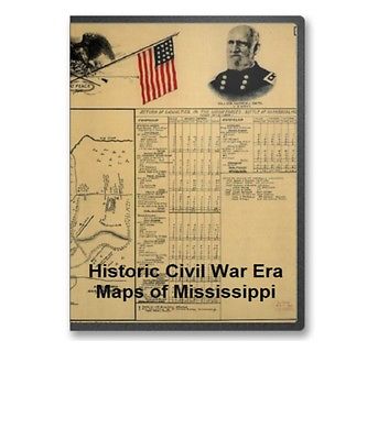
This CD contains 39 rare historic maps and descriptive pages representing fascinating details about Mississippi and its vicinity during the Civil War in MrSid format. This format allows you to see the entire map on your computer screen or drill down to see the smallest details. The original maps are often quite large, as much as 36" long or larger and quite detailed. With the MrSID software, you can manipulate the map to print the entire map in great detail or zoom into a portion of the map in full detail for viewing or printing. You could even bring the images to a local print shop to have the maps reprinted in their full size. (MrSID software is included on the CD.)
To give you a sample of the detail you can expect in these maps, here is an example based on a panoramic map of Washington, DC.
The table below shows the and a small image of each map on this fascinating civil war history CD.
Map of a part of Louisiana and Mississippi, illustrating the operations of the U.S. forces, in the Department of the Gulf Drawn by H. Lindenkohl. E. Moliter lith. United States Coast Survey. CREATED/PUBLISHED S.l. , 1863. NOTES Scale ca. 1:380,160. In margin at bottom: Line of marsh sic of Gen. Banks corps d'armee April & Mai 1863. Map extends from Natchez, Mississippi, in the north to Marsh Island, Louisiana, in the south, and Columbia, Mississippi, in the east to Alexandria, Louisiana, in the west. Roads, railroads, drainage, and towns are shown. Map of battlefield of Big Black River Bridge, Mississippi, showing the positions of the U.S. troops, May 17th 1863 Prepared under the direction of Lieut. P. C. Hains. U.S. Engrs., by F. Mason, Act. Asst. Engineer. Published by authority of the Hon. the Secretary of War. Mason, F. Act. Asst. Engineer. CREATED/PUBLISHED S.l. , Office of the Chief of Engineers, U.S. Army, 1876. NOTES Scale ca. 1:7200. Inset: Cross section of parapet A. 6 x 16 cm. Detailed map indicating "confederate works," Union troop positions and names of commanders, artillery positions, roads, "Vicksburg and Jackson Rail Road," houses, fences, vegetation, drainage, and relief by hachures. No. 1. First Vicksburg campaign or Chicksaw sic Bayou. Dec. 27th 1862-Jan. 3rd 1863.-No. 2. Map of battle ground of Chickasaw Bayou, Dec. 28th and 29th 1862 Enlarged and drawn by E. A. Munn from Gen. Morgan's map. Munn, Edward A. CREATED/PUBLISHED Chicago, Woman's Temperance Publishing Association, 1892 NOTES Scale of map 1, ca. 1:150,000; scale of map 2 not given. Maps indicate troop movements and positions. General plan of the field-fortifications around Corinth, Miss. : also exhibiting the rebel entrenchments and the approaches of the U.S. forces during May 1862 under Major Genl. H. W. Halleck, U.S.A. / surveyed and drawn under the direction of Captain Fred. E. Prime, Corps of Engineers, Chief Engineer, Department of Tennessee ; surveyed and drawn by F. Shraag and F. Theinert. Shraag, F. CREATED/PUBLISHED 1862 NOTES Relief shown by hachures and pictorially. Detailed topographic map showing Union and Confederate fortifications by the colors blue and red respectively, powder magazines, city streets and buildings (both unnamed), rural houses and names of a few residents, fences, roads, railroads, vegetation, drainage, and artesian wells. Map of the country between Monterey, Tenn: & Corinth, Miss: showing the lines of entrenchments made & the routes followed by the U.S. forces under the command of Maj. Genl. Halleck, U.S. Army, in their advance upon Corinth in May 1862: Surveyed under the direction of Col. Geo. Thom, A.D.C. & Chief of Topl. Engrs., Department of the Mississippi, by Lieuts. Fred. Schraag and C. L. Spangenberg, Asst. Topl. Engrs. and drawn by Lieut. Otto H. Matz, Asst. Topl. Engr. Matz, Otto H. CREATED/PUBLISHED N.Y., Lith. of J. Bien, 1862 NOTES Scale 1:31,680. Includes houses, names of residents, fences, roads, railroads, vegetation, fields, drainage, and relief by hachures. Map showing the battle field at Harrisburg, Miss. July 13-15, 1864. Allman, Eugene H. CREATED/PUBLISHED Mobile, Alabama, Aynsley Litho. & Eng. Co. Inc., c1912. NOTES Scale not given. "Legend: This map shows the position of the Confederate and the Federal forces during the three days encounter, showing in detail the position of the several commands. "The tables show the record of casualties, in offices sic and men, killed, wounded and captured during the three days, as compiled from the official records of the Union and Confederate armies, and is authentic. Indicates entrenchments, batteries, roads, towns, vegetation, drainage, and some relief by hachures. There are colored portraits of "Maj. Gen. Nathan B. Forrest, C.S. Army" and "Maj. Gen. Andrew J. Smith, U.S. Army" in the top margin, as well as a drawing of an eagle perched on the crossed flags of the Confederate States and United States with "at peace" printed below the flags. Sketch of rebel fortifications at Hayne's Bluff. United States. Navy. CREATED/PUBLISHED S.l., 1863 NOTES Scale ca. 1:23,000. Map of the battle of Iuka, Mississippi, showing the positions of the United States and Confederate troops on the 19th of September 1862 Accompanying the report of Maj. Gen. W. S. Rosecrans. Published by authority of the Hon. the Secretary of War, office of the Chief of Engineers, U.S. Army. United States. Army. Corps of Engineers. CREATED/PUBLISHED S.l. , 1876. NOTES Scale 1:6336. "The United States forces are shown in blue and the Confederate forces are shown in red." Detailed map indicating roads, the "route to heights commanding Fulton Road," street pattern and buildings in Iuka, houses and names of residents in outlying areas, fences, "Memphis & Charleston R.R.," vegetation, drainage, and relief by hachures. Map of Jackson, Miss: and surroundings during the siege July 10th-16th, 1863, and location of the Cooper home whence a piano was carried by a company of pioneers, commanded by a Capt: McPheely, to the position of 5th Company, Washington (Louisiana) Battery, and there remained during the siege, and played upon while the battle, July 12th, 1863, was in progress. Duff, William H. CREATED/PUBLISHED S.l. , c1908. NOTES Scale not given. Sketch map showing the "Confederate's line of works," positions of "Slocomb's Louisiana Battery" and "Cobb's Kentucky Battery," "Federal line," "Mrs. Cooper's home," railroads, roads, and drainage. Vicksburg National Military Park. Vicksburg National Park Commission. CREATED/PUBLISHED S.l. Topographical survey, 1902. NOTES Scale 1:2500. Large-scale topographic map showing contour lines, drainage, and fortifications in the vicinity of the Alabama and Vicksburg R.R. at Two Mile Bridge. The Vicksburg National Military Park and vicinity showing lines of siege and defense of the city. National cemetery in background. Poole Brothers. CREATED/PUBLISHED Chicago, Poole Bros., c1925. NOTES Scale not given. Panoramic map in which "black lines indicate the Union trenches," "red lines indicate the Confederate line of defense," "white lines show the park roads," and "the stars mark general headquarters." ksburg National Military Park, Miss. Albert Pike, Division Engineer. Topography by Frank Larner, H. G. Warner, and J. G. Harrison. Control by U.S. Geological Survey. Surveyed in 1935. Geological Survey (U.S.) CREATED/PUBLISHED Washington, U.S. Geological Survey, 1935 NOTES Scale 1:9600. Detailed topographic map. Contour interval 10 feet. Includes a detailed list of monuments, markers, batteries, and approaches keyed by number to the map. Vicksburg National Military Park and Vicksburg National Cemetery. United States. National Park Service. CREATED/PUBLISHED S.l. , reprint 1952. NOTES Scale ca. 1:62,000. Illustrates a descriptive leaflet by the U.S. National Park Service entitled "Vicksburg National Military Park, Mississippi." Map indicates Union and Confederate lines, "significant structures" in the park, a park tour, roads, and railroads. Vicksburg National Military Park, Mississippi. United States. National Park Service. CREATED/PUBLISHED Washington , Government Printing Office, 1958. NOTES Scale ca. 1:62,000. Descriptive leaflet illustrated with the following two maps: a Vicksburg National Military Park, Mississippi. Colored. Scale ca. 1:14,400. 11 x 22 cm. (Shows names of commander roads, railroad, and tour route.) b The Vicksburg campaign. Aug. 1962. Colored. Scale ca. 1:2,350,000. 40 x 23 cm. (Map of the Mississippi River from Memphis to the Gulf of Mexico showing drainage, railroads, and towns.) Vicksburg National Military Park, Mississippi. United States. National Park Service. CREATED/PUBLISHED Washington , Government Printing Office, 1963. NOTES Various scales. Descriptive leaflet illustrated with the following two maps: a Vicksburg National Military Park, Mississippi. Colored. Scale ca. 1:14,400. 11 x 22 cm. (Shows names of commander roads, railroad, and tour route.) b The Vicksburg campaign. Aug. 1962. Colored. Scale ca. 1:2,350,000. 40 x 23 cm. (Map of the Mississippi River from Memphis to the Gulf of Mexico showing drainage, railroads, and towns.) Vicksburg National Military Park, Mississippi. United States. National Park Service. CREATED/PUBLISHED Washington, U.S. Govt. Print. Off., 1969 NOTES Scale ca. 1:34,000. Includes descriptive index and illus. Vicksburg National Military Park. United States. National Park Service. CREATED/PUBLISHED Washington, U.S. Govt. Print. Off. 1973. NOTES Scale ca. 1:28,000. Folded title: Vicksburg National Military Park, Mississippi. Includes descriptive index, text, and illus. Approaches to Vicksburg and Rebel defences From a reconnaissance by C. Fendall, Sub. Assist., under the direction of F. H. Gerdes, Assist., assigned by A. D. Bache, Supdt., U.S. Coast Survey, to act under orders of Rear Admiral D. D. Porter, U.S. Navy, commanding Mississippi Squadron. Fendall, C. CREATED/PUBLISHED S.l. 1863. NOTES Scale 1:20,000. Indicates fortifications, names and positions of boats, roads, streets, railroads, canal across De Soto Point, houses, vegetation, drainage, and relief by hachures. Map illustrating the operations of the U.S. forces against Vicksburg. United States Coast Survey. CREATED/PUBLISHED S.l. , J. W. Maedel, 1863 NOTES Scale ca. 1:390,000. "Indicates "Genl. Grant's track," "Union forces surrounding Vicksburg," and "track of Genl. Blair." Roads, railroads, drainage, and towns are shown. "Union victories" are noted by colored U.S. flags. The siege of Vicksburg, its approaches by Yazoo Pass and other routes T. S. Hardee, del. W. R. Robertson, Mobile, Ala., lith. Mobile, S. H. Goetzel & Co., May 1st, 1863. Hardee, T. S. CREATED/PUBLISHED Mobile S. H. Goetzel & Co. 1863 NOTES Scale not given. Gives towns, Fort Pemberton, railroads, drainage, and the location of "Gen. Grant's Army 75000" opposite Vicksburg. Brief notes describe the "land lying between the Mississippi and Yazoo rivers" and the first and second "inland expedition s of the enemy." Map of the siege of Vicksburg, Miss. by the U.S. forces under the command of Maj. Genl. U.S. Grant, U.S. Vls. Maj. F. E. Prime, Chief Engr. Surveyed and constructed under the direction of Capt. C. B. Comstock, U.S. Engrs. and Lt. Col. Js. H. Wilson, A. I. Genl., 1st Lt. Engrs., by Major Otto H. Matz, Ills. Vols., Chs. Spangenberg, Asst. Engr., Lts. Patton, Karnasch & Helmle, Mo. Vols., L. Zwanziger, S. R. Tresilian, B. Barth, S. Hartwell, Asst. Engs. Drawn by Chs. Spangenberg, Asst. Engr. Engr. on stone by J. Schedler, N.Y. Vicksburg, Miss., Head Qrs. of the Dept. of the Tenn., Aug. 20th, 1863. Spangenberg, Charles. CREATED/PUBLISHED Vicksburg, Miss., Head Qrs. of the Dept. of the Tenn., 1863 NOTES Scale ca. 1:17,000 (not "1:15,840"). Detailed map showing entrenchments, roads, streets, railroads, hachures, vegetation, houses, and drainage. Contains five topographic profiles, six cross sections of artillery batteries, and one cross section of a "rebel rifle pit." Vicksburg and its defences. Constructed and engraved to illustrate "The war with the South" Compiled by Charles Sholl Engd. by W. Kemble. Sholl, Charles. CREATED/PUBLISHED S.l. , c1863. NOTES Scale ca. 1:72,500. Caption in lower margin: A topographical map of Vicksburg & its vicinity showing all batteries that were in existence at the time of its fall, with the names of the owners of plantations, &c. Environs of Vicksburg, Mississippi, 1863 / U.S. Coast Survey, A.D. Bache, supdt. United States Coast Survey. CREATED/PUBLISHED Washington, D.C. : The Survey, 1863. NOTES Relief shown by hachures. Depths shown by form lines. Maps of "Yazoo River defences at Walnut Hills" and "Haines Bluff" autogr. by Hausmann. Yazoo River defences at Walnut Hills, near Vicksburg, Miss. : occupied by the U.S. Naval Forces, May 20, 1863 / surveyed for Rear Adminral D.D. Porter, commanding Mississippi flotilla, by sub. asst., C. Fendall -- Haines Bluff, Miss. : showing the positions of the attacking gunboats, April 30th, May 1st, 1863 / sketched by C. Fendall ... under direction of Rear Admiral D.D. Porter -- Vicksburg and vicinity / surveyed by C. Fendall & A. Strausz, under the direction of Real Admiral D.C. Porter -- Survey of a canal connecting Walnut Bayou with the Mississippi River : dug by the U.S. Forces under Genl. Grant in April 1863 / surveyed by C. Fendall & A. Strausz. View of Vicksburg and plan of the canal, fortifications & vicinity Surveyed by Lieut. L. A. Wrotnowski, Top: Engr. Drawn & lithogd. by A. F. Wrotnowski C.E. Wrotnowski, L. A. CREATED/PUBLISHED S.l. , 1863. NOTES Scale 1:63,360. Indicates fortifications, location, type and names of boats, roads, railroads, levees, drainage, vegetation, and the names of a few residents. Inset: View of Vicksburg 17 x 54 cm. linson's map of Vicksburg, showing all the surrounding fortifications, batteries, principal plantation, &c. Tomlinson, G. W. (George W.) CREATED/PUBLISHED Boston, J. Mayer & Co., lith., c1863. NOTES Scale ca. 1:65,000. At top of map: New map of Vicksburg, showing the scene of Gen. Grants operations, together with all of the fortifications, batteries, rifle pits &c. Text to right of map: Sketch of Vicksburg and the surrounding batteries. Map of the siege of Vicksburg.|
|
|