Welcome,
Guest! Login
Login
0 Items
$0.00
$0.00


Login to enter your own
review of this item.
 The Historical Archive is dedicated to creating a large, robust library of DVD and CD based products covering a wide range of significant and interesting historical events and cultural moments through film, photos, audios, maps and other documents. This growing collection of unique, special interest DVDs and CDs covers the full range of significant events that have shaped our culture, entertainment values and history.
Center total is the Seller's overall score, averaged from each active component:
|
Atomic Mall Feedback: Imported Feedback: Order Fulfillment Rate: |
100.0 99.8 100 | |
| Trophies Earned | ||
|
|

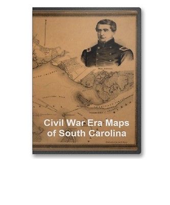
This CD contains 56 rare historic maps and descriptive pages representing fascinating details about South Carolina and its vicinity during the Civil War in MrSid format. This format allows you to see the entire map on your computer screen or drill down to see the smallest details. The original maps are often quite large, as much as 36" long or larger and quite detailed. With the MrSID software, you can manipulate the map to print the entire map in great detail or zoom into a portion of the map in full detail for viewing or printing. You could even bring the images to a local print shop to have the maps reprinted in their full size. (MrSID software is included on the CD.)
To give you a sample of the detail you can expect in these maps, here is an example based on a panoramic map of Washington, DC.
The table below shows the and a small image of each map on this fascinating civil war history CD.
Genl. Sherman's campaign war map. Bufford, John Henry, 1810-1870. CREATED/PUBLISHED Boston, 1864 NOTES Scale ca. 1:670,000. "The horizontal and upright lines of the map grid represent five miles square. By referring sic to the number on the left and to the letter on the base, any point may be found to show the locality of the Union armies." Southern Georgia and part of South Carolina / U.S. Coast Survey, A.D. Bache, supdt. ; drawn by A. Lindenkohl ; Chas. G. Krebs, lith. United States Coast Survey. CREATED/PUBLISHED Washington, D.C. : The Survey, 1865. NOTES Relief shown by hachures. Includes list of authorities. Northern Georgia and western and central South Carolina Drawn by A. Lindenkohl. H. Lindenkohl & Chas. G. Krebs, lith. Lindenkohl, A. CREATED/PUBLISHED S.l. , U.S. Coast Survey, A. D. Bache, Supdt., 1865 NOTES Scale 1:633,600. General map, without title, extending from Charleston west to the western boundary of Georgia. State names, boundaries, and railroads are overprinted in red. Middle Georgia & South Carolina / U.S. Coast Survey, A. D. Bache, supt. ; drawn by A. Lindenkohl ; Chas. G. Krebs, lith. United States Coast Survey. CREATED/PUBLISHED Washington : The Survey, 1865? NOTES Scale ca. 1:633,600; 1 in. = 10 miles. Relief shown by hachures. J. H. Colton's topographical map of North and South Carolina. A large portion of Georgia & part of adjoining states. Entered according to Act of Congress in the year 1861 by J.H. Colton. Colton, J. H. (Joseph Hutchins), 1800-1893. CREATED/PUBLISHED New York Printed by Lang & Laing 1861. NOTES Scale ca. 1:1,550,000. Indicates forts, towns, roads, railroads, county names and boundaries, geographic coordinates, and rivers. Drawings of ships offshore denote naval blockade. Insets: Beaufort and vicinity, N. Carolina. 8 x 9 cm.-Wilmington and vicinity, N. Carolina. 13 x 9 cm.-Charleston Harbor and its approaches, S. Carolina. 14 x 15 cm.-Plan of Ft. Sumter. 4 x 4 cm.-Savannah and vicinity. 10 x 15 cm. North Carolina & South Carolina Drawn by A. Lindenkohl. Chas. G. Krebs, lith. Lindenkohl, A. CREATED/PUBLISHED S.l. , U.S. Coast Survey, A. D. Bache, Supdt., 1865. NOTES Scale 1:633,600. General map. "Authorities" used in making the map are listed below the title. State names, boundaries, and railroads are overprinted in red. Coast line from Charleston to Savannah. CREATED/PUBLISHED 1862? NOTES Scale ca. 1:430,000. Copy of the plot of the city of Beaufort, South Carolina / drawn by B. Schelten, expressily sic for Dr. Clymer, surg. U.S. Schelten, B. CREATED/PUBLISHED 186- NOTES Scale not given. Relief shown by hachures. Includes index of military hospitals and col. ill. of "Chief Office." Broad River and its tributaries, S.C. From a reconnaissance made, under direction of Rear Admiral J. A. Dahlgren, Commd'g S.A.B. Squadron, by R. Platt, Act. Master, U.S.N. und sic E. Willenbucher, U.S.C.S. 1864. Drawn by Eugene Willenbucher. Bowen & Co., lith., Philada. Willenburger, Eugene. CREATED/PUBLISHED Washington, Government Printing Office, 1865 NOTES Scale ca. 1:230,000. Map of Charleston Harbor showing defenses. 186- Section from Atlas accompanying war records U.S.A. by courtesy of Julius Bien & Co. Peter Adams Company. CREATED/PUBLISHED S.l., 18--? NOTES Scale not given. Map of Charleston Harbor, S.C. Bowen & Co. CREATED/PUBLISHED Philada., Bowen & Co's lith., 18--? NOTES Scale ca. 1:15,800. Red curves are marked 6, 12, 18, and 24 feet to show depths at mean low water. The area always covered with water is blue, the surface between high and low water marks is indicated by wavy lines and colored with bistre. Shows drainage, vegetation, cultivated areas, roads, and houses. The forts are circumscribed by 9-inch circles, which show the range of their guns, with the exception of Fort Sumter, where the range is different and is indicated by three radii. Preliminary chart of Charleston Harbor and its approaches. United States Coast Survey. CREATED/PUBLISHED S.l. , Published in 1858. Additions in 1862. NOTES Inscribed in ink: Transferred from Office of Chf. Engr., Defenses of Washington, to Engr. Dept., Jany. 1866. DLC Shows fortifications, towns, soundings, roads and streets, vegetation, and drainage. Includes "view of main ship channel" and "view off north channel." Sketch of Charleston Harbor By W. A. Williams, Civil Engineer. Williams, W. A. CREATED/PUBLISHED Boston, L. Prang & Co., 186-? NOTES Scale ca. 1:70,000. Shows fortifications, street pattern of Charleston, vegetation, and a few soundings. Insets: Castle Pinckney. 7 x 5 cm-Fort Sumpter sic . 7 x 6 cm-Fort Moultrie. 5 x 6 cm. Part of Charleston Harbor, embracing forts Moultrie, Sumter, Johnson, and Castle Pinckney, also Sullivan, James & Morris islands; and showing the position of the Star of the West, when fired into from Morris Island. Perry, George T. CREATED/PUBLISHED Philadela., Lith. P.S. Duval & Son, c1861. NOTES Scale ca. 1:31,000. Shows the channel, drainage, vegetation, roads, plan of the city, and forts. A portrait of Major Anderson, commander of Fort Sumter, is in the upper right corner. Below the neat line is a view of the harbor and city from Fort Johnson to Mt. Pleasant. Plan of Charleston Harbor, and its fortifications compiled by Elliot & Ames from government surveys. Elliot & Ames. CREATED/PUBLISHED Boston, C. D. Andrews' lith., 1861. NOTES Scale 1:31,680. Shows channel, low water mark and soundings, drainage, roads, railroads, some dwellings, a plan of the city, and forts. Charleston Harbor and its approaches showing the positions of the Rebel batteries. United States Coast Survey. CREATED/PUBLISHED N.Y., Lith. of J. Bien, 1863 NOTES Scale 1:30,000. Another issue. Shows roads, railroads, houses, vegetation, a street plan of Charleston, drainage, soundings, and shoals. Overprinted to show 1/4-mile concentric circles centered on St. Michaels, Charleston; positions occupied by the Union Army and Navy; "Rebel batteries in possession of National forces and batteries still held by the Rebels on Sept. 7th 1863." Union positions are based "on the authority of Maj. T. B. Brooks . . ." Charleston Harbor and its approaches showing the positions of the Rebel batteries. United States Coast Survey. CREATED/PUBLISHED S.l, 1863 NOTES Scale 1:30,000 . Another issue. Shows roads, railroads, houses, vegetation, a street plan of Charleston, drainage, soundings, and shoals. Overprinted to show positions occupied by the Union Army and Navy, and "Rebel batteries in possession of National forces and batteries still held by the Rebels on Sept. 7, 1863." Charleston Harbor and its approaches showing the positions of the Rebel batteries. United States Coast Survey. CREATED/PUBLISHED N.Y., J. Bien, lith., 1863 NOTES Scale ca. 1:30,000. Another issue. Shows roads, railroads, houses, vegetation, a street plan of Charleston, drainage, soundings, and shoals. Enlarged issue covering all of James Island and indicating 1/2-mile concentric circles centered on St. Michaels, Charleston, "first and second line s of Rebel defences," positions occupied by the Union Army and Navy, and "Rebel batteries in possession of National forces and batteries still held by the Rebels on Sept. 7th 1863." New map of Charleston Harbor, showing the scene of the great naval contest between the iron clad monitors and the Rebel batteries, also the lines of fire, forts, obstructions, inlets, princl. plantations, & e.t.c. Tomlinson, G. W. (George W.) CREATED/PUBLISHED Boston, Lith. by J. Mayer & Co., c1863. NOTES Scale not given. Shows the coast from Long Island to the North Edisto River. Indicates drainage, roads, railroads, and dwellings with names of inhabitants. Channels, water depths, forts and batteries, with lines of fire, are given. The following title appears in the lower right corner: Tomlinson's map of Charleston Harbor, S.C., and vicinity, showing the fortifications and batteries, together with a full of the harbor, forts, obstructions, bombardment & et.c. Drawings of the Ericsson "Devil" and the iron clad "Keokuk," and plans of Fort Sumter, Fort Moultrie, and Castle Pinckney are in the lower right corner. A column of text entitled " of the harbor, forts, &c." is in the right margin. Charleston Harbor and its approaches showing the positions of the Rebel batteries. United States Coast Survey. CREATED/PUBLISHED S.l. , 1863. NOTES Scale 1:30,000. Shows roads, railroads, houses, vegetation, a street plan of Charleston, drainage, soundings, and shoals. Resurvey of Charleston Bar by W. S. Edwards, Asst. and F. P. Webber, Sub-Asst., under the direction of C. O. Boutelle, Assistant, 1864. Redd. Drng. by J. J. Ricketts & A. Boschke. Engd. by F. Dankworth, J. Knight, E. Yeager & G. McCoy. United States Coast Survey. CREATED/PUBLISHED S.l., 1864 NOTES Scale 1:30,000. "No. 15" is in the upper left corner. Charleston Harbor and city defences Entered according to Act of Congress in the year 1864 by D. N. Dobelmann & G. Huck. Dobelmann, D. N. CREATED/PUBLISHED S.l. , T. B. Usser, 1864. NOTES Scale ca. 1:170,000. "Key to the map of Charleston Harbor and defences" is pasted to the right of the map. "Green represents the Confederates" land and pink the Federal possessions" Indicates "torpedoes in the channels," obstructions, bridges, roads and streets, railroads, and rivers. Letters A to K represent fortifications, headquarters, depots, and "place where Clarck of Brooklin was executed." Forts and batteries are numbered 1 to 40. The number of guns and mortars for each is shown opposite the name given in the "Key" Sketch showing position of besieging batteries. Fort Sumter April 12-13, 1861 Bowen & Co., lith., Phila. Foster, John G. (John Gray), 1823-1874. CREATED/PUBLISHED Washington, Government Printing Office, 1866 NOTES Scale ca. 1:30,800. Map of the defences of Charleston city and harbor, showing also the works erected by the U.S. forces in 1863 and 1864 To accompany the report of Major Genl. Q. A. Gillmore, U.S. Vols. United States. Army. Corps of Engineers. CREATED/PUBLISHED S.l., 186- NOTES Scale 1:60,000. At bottom of map: View off North Channel, For Sumter 3 1/2 miles distant, bearing W. 3/4 N., Febry. 18th 1865. This map without the Corps of Engineers' insignia appears as Plate II of the Supplementary Report published with Q. A. Gillmore's Engineer and Artillery Operations Against the Defenses of Charleston Harbor in 1863; with a Supplement. (New York, D. Van Nostrand, 1868). 314, 172 p. (U.S. Army. Corps of Engineers. Professional papers, no. 16) Shows drainage, vegetation, roads, railroads, soundings, shoals, channels, forts, batteries, picket line of the U.S. forces, plan of the city with the "effective, annoying and extreme range" of guns from Cumming's Point. E. & G. W. Blunt's map of Charleston and vicinity. E. & G.W. Blunt (Firm). CREATED/PUBLISHED New York , 1862. NOTES Scale ca. 1:151,000. Indicates fortifications, roads, railroads, towns, street pattern of Charleston, drainage, vegetation, and ship channels. Charleston and its defences. Philadelphia Inquirer (Firm) CREATED/PUBLISHED Philadelphia, 1863. NOTES Scale ca. 1:52,000. From The Philadelphia Inquirer, Saturday, April 11, 1863, p. 1. Map indicates forts, batteries, obstructions, and torpedoes (i.e., mines) Defences of Charleston, South Carolina From a reconnaissance made by direction of C. O. Boutelle, Asst. U.S.C.S., by E. Willenbucher. 1865. Bowen & Co., lith., Philada. Willenbucher, Eugene. CREATED/PUBLISHED Washington, Government Printing Office, 1865 NOTES Scales 1:2000 and 1:4000. Map of Charleston and vicinity. CREATED/PUBLISHED 1862. NOTES Scale ca. 1:170,000. General map of Charleston Harbor, South Carolina, showing rebel defences and obstructions. Drawn by E. Willenb 1/4cher, Chas. G. Krebs, Lith. Willenbucher, Eugene. CREATED/PUBLISHED Washington 1865. NOTES Scale 1:30,000. Depths shown by gradient tints. Shows location of sunken ships. Includes table of rebel forts. Map of Charleston and its defences Compiled from surveys of portions of St. Andrews and Christ Ch. parishes by Lieut. John Johnson, C.S. Engrs., the harbor, James Id., Folly Id., Morris Id., Sullivans Id., & Long Id., from U.S. Coast Survey, Johns Id., from Mills Atlas. Under the direction of Maj; Wm. H. Echols, C.S. Engr. Corps, by Wm. A. Walker, Draughtsman, C.S. Engr. Corps. Drawn by John R. Key, 2nd. Lieut., C.S. Engr. Charleston, S.C., Nov: 28th, 1863. Walker, William A. CREATED/PUBLISHED S.l., 1885 NOTES Scale 1:63,360 (not "2 inches to 1 mile"). In upper left corner: Copied for his excellency M. L. Bonham Governor of the State of South Carolina. In lower margin: Reproduced for Mayor Courtenay's city year book, from the original map in the possession of the Chamber of Commerce, Charleston, S.C. Detailed map showing forts and batteries, roads, railroads, towns, houses and names of residents, vegetation, drainage, and soundings in Charleston Harbor and offshore. Fort Johnson, section of map of the defences of Charleston Harbor, South Carolina surveyed between March 7th & May 20th, 1865, under the direction of Brevet Major General R. Delafield, Chief Engineer, U.S. Army. Surveyed April 20th, 1865, by J. E. Weyss, Maj., U.S.V.; assisted by Mr. F. Theilkuhl & E. Schumann. United State|
|
|