Welcome,
Guest! Login
Login
0 Items
$0.00
$0.00


Login to enter your own
review of this item.
 The Historical Archive is dedicated to creating a large, robust library of DVD and CD based products covering a wide range of significant and interesting historical events and cultural moments through film, photos, audios, maps and other documents. This growing collection of unique, special interest DVDs and CDs covers the full range of significant events that have shaped our culture, entertainment values and history.
Center total is the Seller's overall score, averaged from each active component:
|
Atomic Mall Feedback: Imported Feedback: Order Fulfillment Rate: |
100.0 99.8 100 | |
| Trophies Earned | ||
|
|

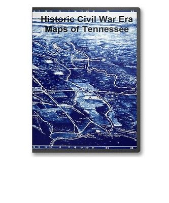
This CD contains 77 rare historic maps and descriptive pages representing fascinating details about Tennessee and its vicinity during the Civil War in MrSid format. This format allows you to see the entire map on your computer screen or drill down to see the smallest details. The original maps are often quite large, as much as 36" long or larger and quite detailed. With the MrSID software, you can manipulate the map to print the entire map in great detail or zoom into a portion of the map in full detail for viewing or printing. You could even bring the images to a local print shop to have the maps reprinted in their full size. (MrSID software is included on the CD.)
To give you a sample of the detail you can expect in these maps, here is an example based on a panoramic map of Washington, DC.
The table below shows the and a small image of each map on this fascinating civil war history CD.
Chickamauga and Chattanooga National Military Park, Ga. (Chickamauga Battlefield). Geological Survey (U.S.) CREATED/PUBLISHED Washington, 1934 NOTES Scale 1:9600. "Advance sheet. Subject to correction." Title at top of sheet: Georgia. Chickamauga and Chattanooga National Military Park (Chickamauga Battlefield). Detailed topographic map indicating monuments and markers. 290 sites are listed and keyed by number to the map. Countour interval is 5 feet. Chickamauga and Chattanooga National Military Park, Georgia and Tennessee : principal roads and streets between Chattanooga and park areas. United States. National Park Service. OTHER TITLES Point Park Lookout Mountain and Chattanooga battlefields CREATED/PUBLISHED Washington , Government Printing Office, 1957 NOTES Scale ca. 1:64,000. Chickamauga and Chattanooga National Military Park. United States. National Park Service. CREATED/PUBLISHED Washington, U.S. Govt. Print. Off. 1968. NOTES Scale ca. 1:95,000. Georgia, Chickamauga and Chattanooga National Military Park (Chickamauga Battlefield) / Department of the Interior, U.S. Geological Survey ; topography by Frank Larner and R. E. Amidon. Geological Survey (U.S.) CREATED/PUBLISHED Knoxville : Tennessee Valley Authority, 1975? NOTES Scale 1:9,600 or 1 in. = 800 ft. Includes compilation diagr. and index of battle monuments and sites. Map of Chickamauga & Chattanooga National Park The Matthews-Northrup Co., Buffalo, N.Y. Nashville, Chattanooga, and St. Louis Railway. OTHER TITLES War route to Chickamauga. Dedication Chickamauga and Chattanooga National Park, September 18, 19, and 20, 1895. CREATED/PUBLISHED Nashville, Nashville, Chattanooga & St. Louis Ry., 1895 NOTES Scale ca. 1:57,000. Map shows roads, railroads, state boundaries, place names, and boundary of national park. "Red lines indicate government roads." Map of Chickamauga and Chattanooga National Military Park Drawn by B. B. Ramey. Copyrighted 1895, by W. E. Birchmore. Engraved by Buff alo Elec. & Eng. Co. Ramey, B. B. CREATED/PUBLISHED S.l. , c1895. NOTES Scale 1:12,000. Map indicates roads, drainage, houses, and names of residents. "Key to monuments, locations, and markers" depicted on map Aero view of Chickamauga and Chattanooga National Military Park (looking east). Painted by Rudolph J. Shutting. Shutting, Rudolph J. CREATED/PUBLISHED Chattanooga, 1913. Knoxville, Tenn., Tennessee Valley Authority, 1974? NOTES Perspective map not drawn to scale. Bird's-eye-view. Indexed for points of interest. Map of the Atlanta campaign. May-Sept. 1864 . Western and Atlantic Railroad Company. CREATED/PUBLISHED S.l., 1887 NOTES Scale ca. 1:830,000. From Century illustrated monthly magazine, v. 34, July 1887. P. 446. Map of the northwest Georgia showing location and date of engagements, railroads, towns, rivers, relief by hachures, and county names and boundaries. New map of Kentucky and Tennessee from authentic reports of county surveyors throughout the states of Kentucky and Tennessee with a new key for measuring distances and specifying localities (which key is secured by copyright.). Campbell and Barlow. CREATED/PUBLISHED Louisville, Ky., Campbell & Barlow, c1861. NOTES Scale ca. 1:600,000. Index to cities counties is printed below the map. General map indicating roads and railroads, county names and boundaries, cities and towns, rivers, and relief by hachures. Some roads and railroads in Kentucky have been colored red and black respectively. A nearly illegible pencil note in the lower right corner states that this map was "Turned into Bureau of Tpl. Eng. by Lieut. O. M. Poe, Top. Engr., August 1861, referred to in his letter of Aug. 17, 1861." Insets: The city of Memphis, Tennessee. 20 x 29 cm.-The city of Louisville, Kentucky. 19 x 32 cm. New map of Kentucky and Tennessee from authentic reports of county surveyors throughout the states of Kentucky and Tennessee with a new key for measuring distances and specifying localities (which key is secured by copyright.). Campbell and Barlow. CREATED/PUBLISHED Cincinnati, Middleton Strobridge & Co., c1861. NOTES Scale ca. 1:690,000. Map is annotated in blue to show the "Great national military rail road" and in red to show the "Great national military road." Military map of the States of Kentucky and Tennessee, within eleven miles of the 35th parallel of latitude or southern boundary of Tennessee; compiled from the best authentic original maps, various documents, and miscellaneous latest sources of information; commenced under the authority of Major General Don Carlos Buell, commanding the Department of the Ohio, by Capt. N. Michler, Corps Topogl. Engrs. U.S.A., continued under Major General H. G. Wright by Maj. L. Sitgreaves Corps Topogl. Engrs. U.S.A., and completed under Major General Ambrose E. Burnside, commanding the Department, by Lieut. Col. J. H. Simpson, Corps Engrs. U.S.A., Chief Engr. in the Department. Drawn by Charles E. Swann, Ass't. Engr. Swann, Charles E., Assistant Engineer. CREATED/PUBLISHED Cincinnati, O., Ehrgott, Forbriger & Co., Lithographers, Engravers & Printers, 1863. NOTES Scale 1:350,000. In this issue Camp Burnside on the Cumberland River is named, the lithographer's name has been revised, and a dotted line representing the "out line of coal field" has been added in the southeastern quadrant. Military map of the States of Kentucky and Tennessee, within eleven miles of the 35th parallel of latitude or southern boundary of Tennessee; compiled from the best authentic original maps, various documents, and miscellaneous latest sources of information; commenced under the authority of Major General Don Carlos Buell, commanding the Department of the Ohio, by Capt. N. Michler, Corps Topogl. Engrs. U.S.A., continued under Major General H. G. Wright by Maj. L. Sitgreaves Corps Topogl. Engrs. U.S.A., and completed under Major General Ambrose E. Burnside, commanding the Department, by Lieut. Col. J. H. Simpson, Corps Engrs. U.S.A., Chief Engr. in the Department. Drawn by Charles E. Swann, Ass't. Engr. Ehrgott, Forbriger & Co., Lithographers, Engraphers sic and Printers, Cincinnati, O. Swann, Charles E. CREATED/PUBLISHED Cincinnati, Ohio, Office of Chief Engineer, Dept. of the Ohio, 1863. NOTES Scale 1:350,000 (5.524 miles to one inch). Detailed map of Kentucky and most of Tennessee showing towns and villages, county seats, iron works and forges, salt works, mills, post offices, existing and proposed railroads, roads, rivers, and limits of coal fields. Map has been annotated in red ink to show the location of "Camp Burnside" on the Cumberland River south of Somerset, Kentucky. Map of Kentucky and Tennessee. CREATED/PUBLISHED S.l., 1864 NOTES Scale ca. 1:6,200,000. From Century illustrated monthly magazine, v. 34, Aug. 1887. p. 596. Title in the lower margin: Map of Hood's invasion of Tennessee. Grierson's route from La Grange to Baton Rouge. April 17-May 2, 1863 . CREATED/PUBLISHED S.l., 1863 NOTES Scale ca. 1:3,625,000. Mountain region of North Carolina and Tennessee / compiled by W. L. Nicholson & A. Lindenkohl, 1863 ; drawn by A. Lindenkohl ; H. Lindenkohl & Chas. G. Krebs, lith. Nicholson, W. L. CREATED/PUBLISHED Washington : U.S. Coast Survey, 1863 NOTES Scale 1:633,600; 1 in. = 10 miles. Relief shown by hachures. Mountain region of North Carolina and Tennessee Compiled by W. L. Nicholson, 1863. Drawn by A. Lindenkohl. H. Lindenkohl & Chas. G. Krebs, lith. Nicholson, W. L. CREATED/PUBLISHED Washington D. C. , U.S. Coast Survey, A. D. Bache Supt., 1863. NOTES Scale 1:633,600. In top margin: Unfinished proof. Map title printed in the lower right corner. Mountain region of North Carolina and Tennessee. Compiled by W. L. Nicholson & A. Lindenkohl, 1863.-With corrections to May, 1864. Drawn by A. Lindenkohl. H. Lindenkohl & Chas. G. Krebs, lith. Nicholson, W. L. CREATED/PUBLISHED S.l. , U.S. Coast Survey, A.D. Bache, Supt., 1864 NOTES Scale 1:633,600. Map of parts of the states of Kentucky, Tennessee, Virginia, North and South Carolina, Georgia, and Alabama, showing relief by hachures, drainage, names and boundaries of states, roads, and railroads. Part of the route of the "proposed military railroad from Nicholasville & Lebanon" is indicated. Mountain region of North Carolina and Tennessee, compiled by W. L. Nicholson & A. Lindenkohl, with corrections to January 1865. Drawn by A. Lindenkohl. H. Lindenkohl & Chas. G. Krebs, lith. Nicholson, W. L. CREATED/PUBLISHED S.l. , U.S. Coast Survey, A. D. Bache, Supt., 1865 NOTES Scale 1:633,600. Map title printed in the top margin. Map covers parts of the states of Kentucky, Tennessee, Virginia, North and South Carolina, Georgia, and Alabama and shows relief by hachures, drainage, names and boundaries of states, roads, and railroads. This edition has been significantly revised in the vicinity of Chattanooga, Tennessee, and Northern Georgia. Chattanooga Tenn. 1863 / G.H. Blakeslee, U.S. Top. Eng. Blakeslee, G. H. CREATED/PUBLISHED 1863. NOTES Sketch map showing fortifications, Union/Confederate picket lines, rifle pits, "Rebel camp s ", roads, railroads, and streams. Relief shown by hachures and spot heights. Map of Chattanooga and vicinity. 1863-1864 Prepared for and presented with compliments of Western and Atlantic R.R. Co. Western and Atlantic Railroad Company. CREATED/PUBLISHED Buffalo, N.Y., Matthews, Northrup & Co., Art-Printing Works, 1864 NOTES Scale ca. 1:310,000. Indicates the battles of Missionary Ridge, Chickamauga Station, Graysville, Chickamauga, Ringgold, and the "battle among the Clouds," roads, railroads, towns, drainage, and relief by hachures. Map of the battlefields of Chattanooga, movement against Orchard Knob. Prepared ... by the Chickamauga and Chattanooga National Park Commission. Compiled and drawn by Edward E. Betts. United States. Chickamauga and Chattanooga National Park Commission. CREATED/PUBLISHED Washington? 1901. Knoxville, Tenn., Tennessee Valley Authority, 1974? NOTES Scale ca. 1:48,000. Relief shown by contours and spot heights. Covers Chattanooga region. attanooga and surrounding battlefields By Reginald Purse. Purse, Reginald. CREATED/PUBLISHED Chattanooga, Purse Printing Co. , c1913. NOTES Scale not given. y-three points of interest are listed in the lower margin and keyed by number to the panoramic map. Battle map of Chickamauga, Georgia. Saturday 19 and Sunday, 20 September 1863. Map of the Chattanooga battle-fields, November, 1863. Orchard Knob, 23d, Lookout Mountain, 24th, Missionary Ridge, 25th. Norwood, Charles W. CREATED/PUBLISHED Chattanooga, c1898. NOTES Scale ca. 1:32,600. -- Scale ca. 1:63,360. The Chickamauga map is divided "into quarter-mile sections, numbered 1 to 20 on the west and east margins, and lettered A to O on the north and sourth." Map indicates approximate troop positions, movements, commanding officers, a few houses and names of residents, roads, "Chatta., Rome & Southern R.R.," and drainage. The Chattanooga map is divided "into half-mile sections, numbered 1 to 19 on the west and east sides, and lettered A to L on the north and south." The map includes positions of "troops only in their critical situations," relief by hachures, drainage, railroads, and the outline of the streets of Chattanooga. Map of a portion of Missionary Ridge, illustrating the positions of Baird's & Wood's div's., Nov. 23, 24 and 25, 1863. Julius Bien & Co. CREATED/PUBLISHED S.l. , Julius Bien & Co., photo. lith., 18-? NOTES Scale ca. 1:11,800. Shows topography by contours, drainage, roads, railroads, and dwellings with names of inhabitants. Names of corps and commanding officers are given. Arrows indicate battle movements. Fisheye view of Chattanooga and vicinity showing troop positions in 1863 . CREATED/PUBLISHED S.l., 1863 NOTES Not drawn to scale. Battlefield of Chattanooga with the operations of the national forces under the command of Maj. Gen. U.S. Grant during the battles of Nov. 23, 24, & 25, 1863 Published at the U.S. Coast Survey Office, from surveys made under the direction of Br. Genl. W. F. Smith, Chief Engr., Mil. Div. Miss. . . . Chas. G. Krebs, lith. Smith, William F. CREATED/PUBLISHED S.l. , U.S. Coast Survey Office, 1863 NOTES Scale ca. 1:42,500. Indicates troop positions, Union and Confederate headquarters, roads, railroads, drainage, vegetation, relief by shading, and the names of a few residents in the outlying areas. Sketch of the battles of Chattanooga, Nov. 23-26, 1863 U.S. Coast Survey Office, A. D. Bache Supdt. From a sketch by Capt. Preston C. F. West, U.S. Coast Survey. Drawn by H. Lindenkohl. Lindenkohl, H. (Henry) CREATED/PUBLISHED S.l., H. Lindenkohl & Chas. G Krebs, Lith., 1863 NOTES Scale 1:63,360. Map of the environs of Chattanooga showing troop positions and movements, roads, railroads, towns, drainage, and relief by shading. Map of the battlefield of Chattanooga Prepared to accompany report of Maj. Genl. U.S. Grant. By direction of Brigd. Genl. W. F. Smith, Chief Engr., Milty. Div. Miss. 1864. Published by authority of the Secretary of War in the office of the Chief of Engrs., U.S.A. 1875. Smith, William F. CREATED/PUBLISHED N.Y., Julius Bien & Co., photo lith., 1875 NOTES Scale ca. 1:26,600 (not "1:20,000"). Gives troop positions, "route of Hooker's command, Nov. 20th," "route of pontoons," "line|
|
|