Welcome,
Guest! Login
Login
0 Items
$0.00
$0.00


Login to enter your own
review of this item.
 The Historical Archive is dedicated to creating a large, robust library of DVD and CD based products covering a wide range of significant and interesting historical events and cultural moments through film, photos, audios, maps and other documents. This growing collection of unique, special interest DVDs and CDs covers the full range of significant events that have shaped our culture, entertainment values and history.
Center total is the Seller's overall score, averaged from each active component:
|
Atomic Mall Feedback: Imported Feedback: Order Fulfillment Rate: |
100.0 99.8 100 | |
| Trophies Earned | ||
|
|

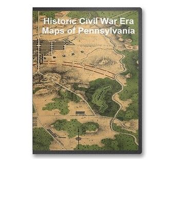
This CD contains 61 rare historic maps and descriptive pages representing fascinating details about Pennsylvania and its vicinity during the Civil War in MrSid format. This format allows you to see the entire map on your computer screen or drill down to see the smallest details. The original maps are often quite large, as much as 36" long or larger and quite detailed. With the MrSID software, you can manipulate the map to print the entire map in great detail or zoom into a portion of the map in full detail for viewing or printing. You could even bring the images to a local print shop to have the maps reprinted in their full size. (MrSID software is included on the CD.)
To give you a sample of the detail you can expect in these maps, here is an example based on a panoramic map of Washington, DC.
The table below shows the and a small image of each map on this fascinating civil war history CD.
Map of reconnaissance of the valley of Brandywine Creek : including the section from Smiths Bridge to the State Road / made under the direction of A.D. Bache, eng'r in charge of the defenses of Philadelphia, Dec. 1863 ; by Henry L. Whiting, asst. U.S. Coast Survey. Whiting, Henry L. CREATED/PUBLISHED 1863. NOTES Topographic map showing roads, railroad, bridges, fortifications, batteries, and various Revolutionary War sites along Brandywine Creek, Chester County, Pennsylvania. Relief shown by contours, hachures, and spot heights. Gettysburg / National Park Service, U.S. Department of the Interior. United States. National Park Service. CREATED/PUBLISHED Washington : The Service, 1978 NOTES Scale ca. 1:27,500. Map of the battlefield of Gettysburg Prepared under the direction of the Gettysburg National Park Commission, Colonel John P. Nicholson, Chairman, Major Wm. M. Robbins, Major C. A. Richardson, L't. Col. E. B. Cope, Engineer and S. A. Hammond, Ass't Engineer. February 1st., 1898. Gettysburg National Military Park Commission. CREATED/PUBLISHED S.l., 1898 NOTES Scale ca. 1:12,000. "No. 1" is in the upper margin. Title and "Explanatory notes" are attached to the map in the lower left corner and a list of "Work on the field accomplished by this Commission to date" is attached to the map in the lower right corner. Map of the battlefield, with manuscript annotations and hand coloring, showing lands belonging to the United States tinted yellow, additional land "needed for the work in hand" tinted green, completed telford roads in red, roads in "need of piking" in black and "public roads ceded to the United States" in blue. Map of one square mile or 1/25 of the battlefield of Gettysburg Surveyed and drawn under the direction of Gettysburg National Military Park Commission, Col. John P. Nicholson, Ch'm., Maj. W. M. Robbins, Maj. C. A. Richardson, Lt. Col. E. B. Cope, Engineer, and S. A. Hammond, Ass't Engineer. Feb. 1st 1898. Gettysburg National Military Park Commission. CREATED/PUBLISHED S.l., 1898 NOTES Scale ca. 1:2400. At top of map: No. 3; Culp's Hill. Map title, legend, and a brief account of the "Work completed on United States property on this square by the Gettysburg National Park Commission," signed by E. B. Cope, Engineer, is attached to the map in the lower left corner. Detailed map of Culp's Hill, with manuscript annotations and hand coloring, showing the extent of U.S. property, telford roads, stone walls, rebuilt stone walls, mounted guns, monuments and markers, lines of earth works, and lunettes for artillery. United States property on the Gettysburg battlefield Gettysburg National Park Commission, Col. John P. Nicholson, Chairman, Major W. M. Robbins, Major C. A. Richardson, and Col. E. B. Cope, C.E. Drawn by H. W. Mattern, Ass't. Feb. 1st, 1898. Gettysburg National Military Park Commission. CREATED/PUBLISHED S.l., 1898 NOTES Scale 1:12,000. "Number 256" is in the upper left corner. Hand-colored and annotated blueprint showing lands "Conveyed by the Gettysburg Battlefield Memorial Association," lands "purchased by the U.S.G.B. Commission and the G.N.P. Commission," and the land devoted to the National Cemetery. Monumental guide to the Gettysburg battlefield. A map showing the location of every monument, marker and tablet with approaching roads and avenues Copyright 1899 by Schuyler A. Hammond & Edgar M. Hewitt. Hammond, Schuyler A. CREATED/PUBLISHED S.l. , c1899. NOTES Scale ca. 1:12,800. Map of the battlefield of Gettysburg from original surveys by the engineers of the Commission By authority of the Secretary of War under the direction of the Gettysburg national Park Commission, Lt. Col. John P. Nicholson, Chairman, Major General L. L. Lomax, Major Charles A. Richardson, Lt. Col. E. B. Cope, Engineer, S. A. Hammond and H. W. Mattern, Asst. Engineers. Drawn by S. A. Hammond, 1903. Gettysburg National Military Park Commission. CREATED/PUBLISHED Washington, Norris Peters Co., 1903 NOTES Scale ca. 1:8350. Detailed map of the battlefield indicating monuments and markers, roads, railroads, stone walls, four types of fences, woodland, and relief by contour lines at intervals of 12 feet. "Property owners name 1903 italics" and "Property owners name 1863 Gothic." Lands owned by the United States are tinted green. Map of Gettysburg battlefield showing routes that must be taken by all wheeled conveyances during the anniversary celebration, from June 28 to June 30, July 1 to 5, 1913 Prepared by direction of the Gettysburg National Park Commission, Col. John P. Nicholson, Chairman, Lt. Col. E. B. Cope, Engineer. Gettysburg National Military Park Commission. CREATED/PUBLISHED S.l., 1913 NOTES Scale 1:21,250. Routes to be followed are shown by red dashed lines. Map of the battlefield of Gettysburg from original surveys by the engineers of the Commission. Under the direction of the Gettysburg National Park Commission. Drawn by S. A. Hammond. Gettysburg National Military Park Commission. CREATED/PUBLISHED n.p. 1914. NOTES Scale ca. 1:8,350. Relief shown by contours and spot heights. Shows 1863 and 1903 landowners and troop positions. Map of the battlefield of Gettysburg from original surveys by the engineers of the Commission By authority of the Hon. Newton D. Baker, Secretary of War, July 1st, 1916, under the direction of the Gettysburg National Park Commission, Lt. Col. John P. Nicholson, Chairman, Major Charles A. Richardson, Lt. Col. E. B. Cope, Engineer. Drawn by S. A. Hammond, Asst. Engineer, 1916. Gettysburg National Military Park Commission. CREATED/PUBLISHED Philadelphia, John T. Palmer Co., 1916 NOTES Scale ca. 1:8450. Another edition. The map was redrawn for this edition. Map of the Gettysburg battlefield Prepared by direction of the Gettysburg National Park Commission, Col. John P. Nicholson, Chairman, Col. E. B. Cope, Engineer. May, 1921. Gettysburg National Military Park Commission. CREATED/PUBLISHED S.l., 1921 NOTES Scale ca. 1:21,250. Map indicates roads, park towers, and the location of the cyclorama. Troop positions are not indicated. The battle of Gettysburg. February 1948, revised 1951. United States. National Park Service. CREATED/PUBLISHED Washington, Government Printing Office, 1957 NOTES Scale ca. 1:60,000. In its Gettysburg National Military Park, Pennsylvania. Washington, Government Printing Office, 1957 Insert: Cavalry battlefield, Scale ca. 1:60,000. 4 x 3 cm. Indicates troop positions and movements, roads, railroad, drainage, relief by hachures, principal points of interest, and a suggested tour route. Gettysburg National Military Park, Pennsylvania. United States. National Park Service. CREATED/PUBLISHED Washington, U.S. Govt. Print. Off. 1973 NOTES Scale ca. 1:28,000. Gettysburg National Military Park, Pennsylvania / National Park Service, U.S. Department of the Interior. United States. National Park Service. CREATED/PUBLISHED Washington : The Service, 1982 NOTES Relief shown by shading. Plan of Gettysburg with the battlefield of July 2nd & 3rd, 1863 and the National Cemetery. Meisel, Augustus. CREATED/PUBLISHED S.l. , A. Meisel, lith., 18--? NOTES Scale 1:7920. Inset: Plan of the National Cemetery. Uncolored. 26 x 16 cm. Shows troop positions, roads, railroads, streams, and a few houses. Map of Gettysburg and vicinity / drawn by Gaylord Weeks, Denison, Iowa. Weeks, Gaylord. CREATED/PUBLISHED 1863 NOTES Shows Civil-War battle positions in rural districts surrounding Gettysburg (Pa.). Union lines are shown by blue dashes and Confederate lines by red ones. Also shows locations of artillery, significant features of the battlefield, some dwellings with names of residents, vegetation, drainage, roads, and railways. The battlefield of Gettysburg, July 1st, 2d, 3d, 1863, showing the movements of the 12th Army Corps. Goodhue, W. F. CREATED/PUBLISHED S.l., 1863 NOTES Scale ca. 1:21,250. Shows drainage, vegetation, roads, railroads, houses and names of inhabitants, and points of interest on the battlefield. In addition to the movements of the 12th Army Corps, the Union and Confederate positions are shown, with names of the commanding officers of some units. Gettysburg battle-field. Battle fought at Gettysburg, Pa., July 1st, 2d & 3d, 1863 by the Federal and Confederate armies, commanded respectively by Genl. G. G. Meade and Genl. Robert E. Lee Jno. B. Bachelder, del. Endicott & Co., lith, N.Y. Bachelder, John B. (John Badger), 1825-1894. CREATED/PUBLISHED Boston and New York, Jno. B. Bachelder, c1863. NOTES Scale not given. Inset: Plan of the Soldiers National Cemetery. Uncolored. 6 x 13 cm. Bears a "Proof" mark in the lower left corner. Endorsed (facsim.): I am perfectly satisfied with the accuracy with which the topography is delineated and the position of the troops laid down. Signed Geo. G. Meade, Maj. Gen. of Vols. comd. A. P. The reproduced signatures of A. Doubleday, John Newton, Winf. St. Hancock, D.B. Birney, Geo. Sykes, John Sedgwick, O. O. Howard, A. S. Williams, and H. W. Slocum appear below the following statement: The positions of the troops of our respective commands represented upon this picture have been arranged under our immediate direction and may be relied upon as substantially corrct. Colored bird's-eye view showing the topography of the battlefield by the perspective of the drawing, shading and coloring. Drainage, vegetation, roads and strets, railroads, bridges, houses and names of residents, fences, points of interest on the battlefield, including designations of places where officers were killed or wounded, are indicated. The locations of the corps, divisions, brigades, etc. of both armies, with the names of commanding officers, are given in detail. Badge symbols are used to identify the Federal corps. Map showing the positions occupied by the Tenth New York Cavalry in the cavalry engagements on the right flank at Gettysburg, Penn. : on July 2 & 3, 1863, between the Union cavalry under Gen. D. McM. Gregg and the Confederate cavalry under Gen. J.E.B. Stuart. Presto, Noble D. CREATED/PUBLISHED 1891? NOTES Finished ms. version of later printed map showing Federal cavalry positions and movements, camp and barracks of the 10th N.Y. Cavalry in 1861-62, drainage, vegetation, roads, streets, railroad, houses, and names of occupants. Covers troop positions in rural areas east of Gettysburg. Relief of hills shown by form lines. Map of the battle field of Gettysburg. July 1st, 2nd, and 3rd 1863 T. Sinclair's lith. Entered according to an Act of Congress in the year 1863 by J. B. Lippincott & Co. . . J.B. Lippincott Company. CREATED/PUBLISHED Philadelphia, J. B. Lippincott, 1864 NOTES Scale 1:15,840. Indicates Union positions in red and Confederate positions in blue, Union artillery positions, roads, railroads, houses and names of residents, drainage, and vegetation. Plan of the Gettysburg battle ground. Reed, Charles Wellington, 1841-1926. CREATED/PUBLISHED S.l. , Chas. W. Reed, 9th Mass. Battery, c1864. NOTES Scale ca. 1:36,500. Map gives Union positions in black and Confederate positions in red, batteries and lines of fire, roads and streets, vegetation, drainage, and relief by hachures.
Map of the battle field of Gettysburg. July 1st, 2nd, 3rd, 1863 Published by authority of the Hon. the Secretary of War, office of the Chief of Engineers, U.S. Army, 1876. Positions of troops compiled and added for the Government by John B. Bachelder. Bachelder, John B. (John Badger), 1825-1894. CREATED/PUBLISHED Boston, John B. Bachelder, 1876. NOTES Scale 1:12,000. "Topography engraved by Julia Bien . . . N.Y. Positions & lettering by Louis E. Neuman . . . N.Y." "Printed by Endicott & Co. . . . N.Y." The maps are entitled: First day's battle. Second day's battle. Third day's battle. "The map is reduced from one on a scale of 200 feet to the inch, deposited in the Archives of the office of the Chief of Engineers. The survey was ordered by Brevet Major General A. A. Humphreys, Chief of Engineers, and conducted under Brevet Major General G. K. Warren, Major of Engineers." An extremely detailed topographic map with spot elevations and contours "given for every change of 4 feet in elevation." Drainage, vegetation, roads, railroads, fences, houses with names of residents, and a detailed plan of the town of Gettysburg are shown. "Every object is represented here as near as possible as it was at the time of the battle." A very minute analysis of the deployment of the various units of both armies, with the names of commanding officers, period of time spent in a particular position, and other pertinent information is given. Dotted lines and arrows indicate the movements of the troops, and the positions at various times of the day are shown by symbols explained in the legend.
Map of the field of operations of Gregg's (Union) & Stuart's (Confederate) cavalry at the battle of Gettysburg, July 3, 1863 Surveyed by Frank O. Maxson, C.E. under the direction of John B. Bachelder, authorized by Act of Congress, approved June 9th, 1880. Bachelder, John B. (John Badger), 1825-1894. CREATED/PUBLISHED S.l., Julius Bien & Co. lith., 1880 NOTES Scale 1:12,000. The maps are entitled "No. 4a. 6-8 P.M., July 2," "No. 10. 4-11 A.M., July 3," "No. 11. 11 A.M.-2 P.M., July 3" and "No. 12. 2-5 P.M., July 3." Detailed topograp|
|
|