The Historical Archive is dedicated to creating a large, robust library of DVD and CD based products covering a wide range of significant and interesting historical events and cultural moments through film, photos, audios, maps and other documents. This growing collection of unique, special interest DVDs and CDs covers the full range of significant events that have shaped our culture, entertainment values and history.
Due to the unique nature and low volume sales of many of our titles, we utilize publish on demand technologies [DVD-R/CD-R] to guarantee delivery of a high quality product at the time of order - ensuring that all orders are fulfilled in a timely manner.
All orders are shipped within two business days via first class mail/international air mail.
0 units sold
No product attributes have been entered for this item.
No warranty info available for this item.
We offer a 30 day no questions asked refund policy on all our CDs and DVDs. If the product is returned within 30 days, a full refund of the purchase price will be issued provided there is no damage to the product - which includes scratches, fingerprints, etc, on the disks. In that instance, we reserve the right to charge a 20% restocking fee. S&H is not refundable.
Description
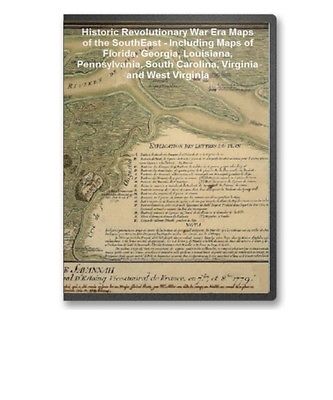
The Historical Archive Sample Page Historic Revolutionary War Era Maps of the SouthEast - Including Maps of Florida, Georgia, Louisiana, Pennsylvania, South Carolina, Virginia and West Virginia
This CD contains 69 rare antique maps and descriptive pages representing fascinating details about the South Eastern United States and its vicinity during the Revolutionary War in MrSid format. This format allows you to see the entire map on your computer screen or drill down to see the smallest details. The original maps are often quite large, as much as 36" long or larger and quite detailed. With the MrSID software, you can manipulate the map to print the entire map in great detail or zoom into a portion of the map in full detail for viewing or printing. You could even bring the images to a local print shop to have the maps reprinted in their full size. (MrSID software is included on the CD.)
To give you a sample of the detail you can expect in these maps, here is an example based on a panoramic map of Washington, DC.
The table below shows the and a small image of each map on this incredible history CD.
Carte de la Florida, de la Louisiane, et pays voisins : pour servir l'Histoire g n rale des voyages / par M. B., ing. de la marine, 1757. . Bellin, Jacques Nicolas, 1703-1772. CREATED/PUBLISHED Paris : J. F. La Harpe, 1780 NOTES Scale ca. 1:10,000,000. Relief shown pictorially. Pansacola o Santta Mar a de Galbe, puerto y presidio del Ry. de Espa a situado en la costa del nortte del Seno Mexicano, los 30 grados 25 mins. de lattd. nortte y los 286 grados y 37 ms. de longd. desde Tenerife 265 leguas inglesas o 227 espa olas al nordestte 1/4 al nortte de la Veracruz i 185 leguas inglesas o 162 espa olas al nordeste 1/4 al nortte de la Havana. . CREATED/PUBLISHED ca. 1760 NOTES Scale ca. 1:165,000. Prime meridian: Tenerife. Soundings shown in fathoms. Includes descriptive text. A plan of the harbour of Pensacola in West-Florida. Surveyed in the year 1764 by George Gauld, M.A. The bar by Sir John Lindsay. . Gauld, George. CREATED/PUBLISHED 1764 NOTES Scale ca. 1:32,500. Manuscript, pen-and-ink and watercolor, on vellum. Soundings shown in fathoms at low tide. Includes "Remarks." Plano de la bahia de Pansacola. Copiado pr. el pilotin del No. Dn. Josef Magule bajo la correccion del Alf rez de frag a ta Dn. Pedro Rivelles, mro. delineador por S. M. del Departam en to de Cadiz su original levantado el a o de 82, por Dn. Antonio Donato Paredes. . CREATED/PUBLISHED 1782 NOTES Scale ca. 1:60,000. Relief shown pictorially. Depths shown by soundings. Shows forts, churches, and Campbelltown pictorially. Includes sailing directions for entering the bay. A Plan of the town of Pensacola, 1767. . CREATED/PUBLISHED 1767 NOTES Scale 1:9,600; 800 ft. to an in. Relief shown by hachures. Cadastral map. A plan of Pensacola and its environs in its present state, from an actual survey in 1778. . Purcell, Joseph. CREATED/PUBLISHED 1778 NOTES Scale ca. 1:4,000. Relief shown by hachures. Cadastral map. Indexed. A plan of the land between Fort Mossy and St. Augustine in the province of East Florida. Sam Roworth, dept. survr. genl. . Roworth, Sam. CREATED/PUBLISHED 176-? NOTES Scale ca. 1:7,900. Oriented with north to the right. Shows "Spanish old fields overgrown with scrubs." Plan of the town and harbour of St. Augustine. . Jefferys, Thomas, d. 1771. CREATED/PUBLISHED London? 1762? NOTES Scale ca. 1:47,000. Oriented with north to the right. Relief shown pictorially. Depth shown by soundings. Plano de la ciudad y puerto de San Agustin de la Florida. . L pez de Vargas Machuca, Tom s, 1731-1802. CREATED/PUBLISHED Madrid, 1783. NOTES Scale ca. 1:49,000. Relief shown pictorially. Soundings shown in feet. Includes map of Florida and western Cuba ca. 1:7,000,000 A map with part of the Florida coast from Cape Blaise to Apalachie; with the boundaries betwixt East & West Floridas, 160 yards across the river call'd Apalachicola. Robt. Slowley of Hs. Ms. sloop Druid, fecit September the 4th, 1769. . Slowley, Robert. CREATED/PUBLISHED 1769 NOTES Scale ca. 1:205,000. Depths shown by soundings. Map of West Florida. B. Romans, inv. delin. & in re incidit. . Romans, Bernard, ca. 1720-ca. 1784. CREATED/PUBLISHED New York, 1781 NOTES Scale ca. 1:500,000. Relief shown by hachures. Depths shown by soundings. A plan of the inlets & rivers of Savannah & Warsaw in the Province of Georgia. . Yonge, Henry. CREATED/PUBLISHED 1751. NOTES Scale ca. 1:32,000; 220 chains, 80 to a mile & 1/2 mile to an in. Relief shown pictorially. Depths shown by soundings. Oriented with north to the right. Shows area between Savannah and Wilmington rivers and west to Savannah in Chatham County. Includes text. Savannah and its environs. . CREATED/PUBLISHED 1779 NOTES Scale ca. 1:24,000. Oriented with north toward the lower left. Relief shown by hachures. Shows the siege of Savannah, 1779. Si ge de Savannah fait par les troupes fran oises aux ordres du g n ral d'Estaing vice-amiral de France, en 7.bre, et 8.bre 1779. . Ozanne, Pierre, 1737-1813. CREATED/PUBLISHED 1779 NOTES Scale ca. 1:27,000. Relief shown by shading. Pictorial map. Includes index to points of interest and descriptive notes. A map of Canada and the north part of Louisiana with the adjacent countrys. By Thos. Jefferys, geographer to His Majesty, 1762. . CREATED/PUBLISHED London 1768 NOTES Scale ca. 1:8,000,000. Relief shown pictorially. A map of Canada and the north part of Louisiana with the adjacent countrys. By Thos. Jefferys, geographer to His Majesty, 1762. . CREATED/PUBLISHED London 1768 NOTES Scale ca. 1:8,000,000. Relief shown pictorially. Shows the Pacific Coast from 400 N. lat. to 600 N. lat. A new & accurate map of Louisiana, with part of Florida and Canada, and the adjacent countries. Drawn from surveys, assisted by the most approved English & French maps & charts, the whole being regulated by astronl. observations. By Eman. Bowen. . Bowen, Emanuel, d. 1767. CREATED/PUBLISHED London, 1752 NOTES Scale ca. 1:8,500,000. Relief shown pictorially. "West longitude from London." Carte de la Louisiane et des pays voisins d di e M. Rouill s cretaire d' tat, ayant le D partement de la marine. Par le Sr. Bellin ingr. ordre. de la marine, 1750. . Bellin, Jacques Nicolas, 1703-1772. CREATED/PUBLISHED Paris? between 1755 and 1762 NOTES Scale ca. 1:5,700,000. Hand colored. Relief shown pictorially. Canada et Louisiane, par le Sr. le Rouge ing nieur g ographe du Roy. . Le Rouge, Georges-Louis. CREATED/PUBLISHED Paris, 1755. NOTES Scale ca. 1:4,450,000. Relief shown pictorially. Includes illus. of Niagara Falls and additional place-names. Carte de la Louisiane et des pays voisins, d di e M. Rouill , s cretaire d' tat, ayant le D partement de la marine. Par le Sr. Bellin, ingr. ordre. de la marine, 1750. . Bellin, Jacques Nicolas, 1703-1772. CREATED/PUBLISHED Paris? 1755? NOTES Scale ca. 1:5,800,000. "Longitude du m ridien de l' le de Fer." Covers the area from Qu bec to the Gulf of Mexico and west of Santa F , N.M. Relief shown pictorially. Shows cities and towns, forts, some trails, and Indian villages and tribal territory. Carte du Canada et de la Louisiane qui forment la Nouvelle France et des colonies angloises ou sont representez les pays contestez. . Nolin, Jean Baptiste, 1686-1762. CREATED/PUBLISHED Paris, Chez Daumont, 1756. NOTES Scale ca. 1:5,000,000. Relief shown pictorially and by hachures. Carte de la Louisiane et pays voisins, pour servir a l'Histoire g n rale des voyages. Par M. B., ing. de la marine. . Bellin, Jacques Nicolas, 1703-1772. CREATED/PUBLISHED Paris? 1757. NOTES Scale ca. 1:10,000,000. Relief shown pictorially. Carte de la Louisiane et des pays voisins d di e M. Rouill s cretaire d' tat, ayant le D partement de la marine. Par le Sr. Bellin ingr. ordre. de la marine, 1750. . Bellin, Jacques Nicolas, 1703-1772. CREATED/PUBLISHED Paris? 1763? NOTES Scale ca. 1:5,700,000. Relief shown pictorially. "Sur de nouvelles observations on a corrig las lacs, et leurs environs, 1755." Amplissima regionis Mississipi seu provinci Ludovician R.P. Ludovico Hennepin Francisc Miss. in America septentrionali anno 1687 detect , nunc Gallorum coloniis et actionum negotiis toto orbe celeberrim . Nova tabula edita Io. Bapt. Homanno, S.C.M. geographo. . Homann, Johann Baptist, 1663-1724. CREATED/PUBLISHED Norimberg 1763? NOTES Scale ca. 1:6,500,000. Relief shown pictorially. La Louisiane et pays voisins. . Bellin, Jacques Nicolas, 1703-1772. CREATED/PUBLISHED Paris, 1764 NOTES Scale ca. 1:10,000,000. Relief shown pictorially. "Longitude occidentale du m ridien de Paris." Carte des possessions fran oises et angloises dans le Canada, et partie de la Louisiane, 1756. L. Thevenard fil. sculp. . Longchamps, g ographe. CREATED/PUBLISHED Paris 1769 NOTES Scale ca. 1:3,900,000. Relief shown pictorially. Includes map extension entitled "Supplement pour les possessions fran oises et angloises au sud de la Louisiane. Grav par Chambon." Carte de la coste de la province de la Louisiane et des bouches du Micissipy ou fleuve St. Louis, faite par Jean Lefargue, Bayonne, le 20 fevrier, 1768. . Lefargue, Jean. CREATED/PUBLISHED 1768 NOTES Scale ca. 1:700,000. Soundings shown in fathoms. Shows the coast from "Baye de l'Ascencion," Louisiana to "Baye St. Joseph," Florida. Plan of New Orleans the capital of Louisiana; with the disposition of its quarters and canals as they have been traced by Mr. de la Tour in the year 1720. . Jefferys, Thomas, d. 1771. CREATED/PUBLISHED London 1759. NOTES Scale ca. 1:5,000. Insets: The course of Mississipi River, from Bayagoulas to the sea ca. 1:800,000 --The east mouth of the Mississipi, with the plan of Fort la Balise which defends the entrance and channel of that river ca. 1:40,000 La Luisiana cedida al Rei N. S. por S. M. Christianisima, con la Nueva Orleans, isla en que se halla esta ciudad. Construida sobre el mapa de Mr. d'Anville. Por D. Thom s Lopez. . L pez de Vargas Machuca, Tom s, 1731-1802. CREATED/PUBLISHED Madrid, 1762. NOTES Scale ca. 1:1,250,000. Relief shown pictorially. "Longitud de la isla del Hierro." Shows Mississippi Valley north to the Canadian border. Includes inset of "Plano de la Nueva Orleans segun el de M. Bellin," ca. 1:5,370, with index to points of interest. A map of Louisiana, with the course of the Missisipi, and the adjacent rivers, the nations of the natives, the French establishments and the mines; by the author of ye History of that colony. 1757. . Le Page du Pratz, d. 1775. CREATED/PUBLISHED London, Printed for T. Becket and P. A. De Hondt, 1763 NOTES Scale ca. 1:8,500,000. Relief shown pictorially and by hachures. Suite du cours du fleuve St. Louis depuis la rivi re d'Iberville jusq' celle des Yasous, et les parties connues de la Rivi re Rouge et la Rivi re Noire. . Bellin, Jacques Nicolas, 1703-1772. CREATED/PUBLISHED Paris, 1764 NOTES Scale ca. 1:830,000. Relief shown pictorially. Prime meridian: Paris. Includes "Remarques sur la Rivi re Rouge" and inset "Carte de l'establissement fran ois sur la Rivi re Rouge." A Map of the country round Philadelphia including part of New Jersey, New York, Staten Island, & Long Island. . CREATED/PUBLISHED London, 1776 NOTES Scale ca. 1:1,625,000. Relief shown pictorially. "West longitude from London." Plan de la retraite de Barren Hill en Pensilvanie : ou un d tachement de deux mille deux cent hommes sous le G'al LaFayette tois entour par l'Arm e angloise sous les G'als Howe, Clinton et Grant le 28 May 1778 / par M'r Capitaine, A.d.C. du G n ral LaFayette. . Capitaine du Chesnoy, Michel, 1746-1804. OTHER TITLES Title on ms. label affixed to cloth backing: Plan de la retraite de Barren Hill en Pensilvanie le 28 May 1778 CREATED/PUBLISHED 1778 NOTES Covers Barren Hill and vicinity (Whitemarsh Twp., Montgomery Co., Pa.) with Chestnut Hill and Germantown. Relief shown by hachures. Place-names in English. Includes descriptive index of American, English, and Hessian military positions. Battle of Brandywine, 11 Septr. 1777. . CREATED/PUBLISHED 1777 NOTES Scale ca. 1:13,000. Relief shown by shading. Battle of Brandywine, 11th Septr. 1777, in which the rebels were defeated by the Army under the command of Genl. Sir Willm. Howe. . CREATED/PUBLISHED 1777 NOTES Scale ca. 1:14,500. Relief shown by shading. Includes list of troops and "References." A plan of the city and environs of Philadelphia, survey'd by N. Scull and G. Heap. Engraved by Will Faden. . Scull, Nicholas, 1686?-1761? CREATED/PUBLISHED London, W. Faden, 1777. NOTES Scale ca. 1:43,000. Shows roads and the names of landholders in rural areas. Includes table of distances and illus. of "Elevation of the State House." A map of Philadelphia and parts adjacent : with a perspective view of the State-House / by N. Scull and G. Heap ; L. Hebert sculpt. . Scull, Nicholas, 1686?-1761? OTHER TITLES Perspective view of the State-House CREATED/PUBLISHED Philadelphia : N. Scull et al., 1752 NOTES Rural buildings shown pictorially with occupants' names. Includes text, distance table, and ground-level view of the Statehouse (later Independence Hall). A survey of the city of Philadelphia and its environs shewing the several works constructed by His Majesty's troops, under the command of Sir William Howe, since their possession of that city 26th. September 1777, comprehending likewise the attacks against Fort Mifflin on Mud Island, and until it's reduction, 16th November 1777. Surveyed & drawn by P. Nicole. . CREATED/PUBLISHED 1777? NOTES Scale 1:14,400; 400 yards to an in. Relief shown by shading. Annotated: John Montresor, chief engineer. Map sections individually titled: Fort Mifflin on Great Mud Island 1:2,400 --Plan of the attacks against the rebels works on Mud Island surrender'd 16. November 1777 1:7,200 --View of the rebel fort and works, on Mud Island comprehending Red-Bank on the Jersey shore; taken from * in front of the 6 gun battery Elevation of the commanding officer's house Section through A:B 1:600 . Copy of a sketch of the Monongahela, with the field of battle, done by an Indian. . CREATED/PUBLISHED 1755? NOTES Scale not given. Relief shown by hachures. In this map the name Ohio R. ou la belle rivi re is applied also to th
 Login
Login


 The Historical Archive is dedicated to creating a large, robust library of DVD and CD based products covering a wide range of significant and interesting historical events and cultural moments through film, photos, audios, maps and other documents. This growing collection of unique, special interest DVDs and CDs covers the full range of significant events that have shaped our culture, entertainment values and history.