Welcome,
Guest! Login
Login
0 Items
$0.00
$0.00


Login to enter your own
review of this item.
 The Historical Archive is dedicated to creating a large, robust library of DVD and CD based products covering a wide range of significant and interesting historical events and cultural moments through film, photos, audios, maps and other documents. This growing collection of unique, special interest DVDs and CDs covers the full range of significant events that have shaped our culture, entertainment values and history.
Center total is the Seller's overall score, averaged from each active component:
|
Atomic Mall Feedback: Imported Feedback: Order Fulfillment Rate: |
100.0 99.8 100 | |
| Trophies Earned | ||
|
|

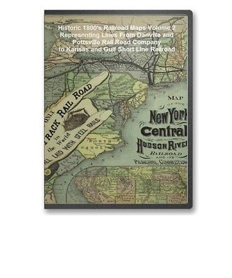
The Railroad maps represent an important historical record, illustrating the growth of travel and settlement as well as the development of industry and agriculture in the United States. They depict the development of cartographic style and technique, highlighting the achievement of early railroaders. Included in the collection are progress report surveys for individual lines, official government surveys, promotional maps, maps showing land grants and rights-of-way, and route guides published by commercial firms.
Below is a small sampling of the maps on this CD. And below the maps is a table with a of the entirety of the maps offered on this CD. Each map is stored in MrSID format.
This format allows you to see the entire map on your computer screen or drill down to see the smallest details. The original maps are often quite large, as much as 36" long or larger and quite detailed. With the MrSID software, you can manipulate the map to print the entire map in great detail or zoom into a portion of the map in full detail for viewing or printing. You could even bring the images to a local print shop to have the maps reprinted in their full size. (MrSID software is included on the CD.)
To give you a sample of the detail you can expect in these maps, here is an example based on a panoramic map of Washington, DC.
Danville, Olney, and Ohio River Railroad . Map of the Danville, Olney & Ohio River Railroad and its connections. Map of the north-central states showing drainage, cities and towns, township and county boundaries, coal fields in Illinois, and the railroad network with emphasis on the main line. G.W. & C.B. Colton & Co. CREATED/PUBLISHED New York, 1881. Scale 1:1,267,200.Duluth and Winnipeg Railway Company . Map showing the route of the Duluth & Winnipeg Railroad and its connections. p shows the north-central states with drainage, cities and towns, and the railroad network indicated. Emphasizes the main line. G.W. & C.B. Colton & Co. CREATED/PUBLISHED New York, 1881. Scale 1:2,217,600.
Florida Transit and Peninsula Railroad . Maps showing the Florida Transit and Peninsula Rail Road and its connections. Maps of southern United States. Main map covers Floria and vicinity and indicates drainage, cities and towns, township and county boundaries, railroads, and the land grant in central Florida. General map shows connections to southern and Gulf states. G.W. & C.B. Colton & Co. CREATED/PUBLISHED New York, 1882. Scale 1:1,140,000 and 1:3,800,000.
Great Central Railway (U.S.) . International rail road guide of the Great Central Route. Shows railroad lines in the north-central and northeastern United States connecting with the Michigan Central and New York Central Railroads. Tunis, W. E. CREATED/PUBLISHED Niagara Falls, N.Y., 1855? Scale ca. 1:4,000,000.
(The above are some of the maps on this CD)This CD Contains 61 Railroad Maps from Railroad Lines Danville and Pottsville Rail Road Company to Kansas and Gulf Short Line Railroad. Here is a list of all the Railroad Lines represented.
Each map contains a wealth of interesting details to explore over and over again. This is a must have collection for any 19th century American railroad buff. With this CD, you will be able to trace the old railroads that made this country great in the 19th century and learn many interesting facts about the various railroad lines both from the provided s and the detailed annotations found on many of the maps.
To use this software, you must install the free ExpressView MrSid software which is included on the CD. This is a 30 second process and will allow you to view and manipulate/print all the maps in this CD collection in full detail. There is a version for both Windows platforms and full installation instructions are included on the CD.
Please visit Our About Me Page to Learn More about Us!
This product is a CD.
All our CDs are professionally produced and packaged in DVD sized cases. This allows you to easily store them with your on your shelf and retrieve them easily. Some of our CDs require a special viewer to be installed on your computer to view the images.
View Our Other Products: To view a listing of all our hundreds of products currently available, click the link below:
View All Products<--
(Note: This will open a new browser window. )
Our payment processor is PayPal
All items are covered by a 30 day money back guarantee. Only the purchase price is refunded. Shipping is not refunded. Item must be sent back at buyer's expense and buyer must include the auction ID and method of payment with the item to receive a refund.
xygooberpie123
Feedback: We give positive feedback to all our paying customers at the time your product is shipped. To purchase your CD for immediate delivery,
just click on the Buy It Now button at the bottom of the page.
|
|
|